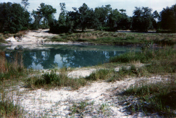
LOCATION: (lat. 28°32'08.3" N., long. 82°32'31.0" W.)
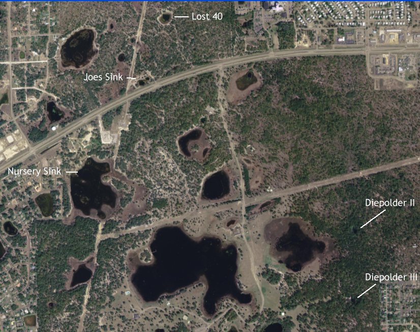
The Lost Forty is located in Hernando County, North of Hwy 50, about a mile East of the Weeki Wachee intersection of US19 and Hwy 50. Look for the power lines and Joes Sink, it's roughly a quarter mile North, in the woods.
DESCRIPTION:
Unlike Joes Sink which has a traditional hourglass
shape, the Lost Forty is more of a horizontal cavern that cuts back under
the East wall of the basin, sloping down to a depth of 160'. Like most
sinks in the area, visibility varies according to runoff and time of year,
it's usually around 15ft. but can get crystal clear at depth. You'll find
the same cold water that Joe's Sink is known for here so dress warm. Be
wary of "redneck leftovers", broken beer bottles, sharp/rusting metal objects,
etc. and the very slippery clay as you enter and exit.
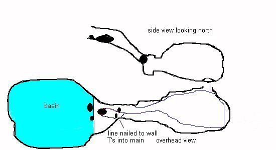
There is a "T" in the line in the back of the room that disappears
into a gopher hole, it was reportedly laid by Sheck himself. The passage
must have been larger at the time, because years of sediment have filled
it in to the point where it is no longer passable. If you have any knowledge
of where this line leads to, please contact me.
DIVELOG:
We entered the basin from the South side, this seems to be the preferred point of entry. In order to avoid kicking up a bunch of surface silt, I donned everything but my fins, inflated my wings and marched through the soft clay and right over the drop-off. After a quick gear check, we followed the sloping bottom, stopping to peruse the usual "artifacts" one would expect to find in a sinkhole. There are several large tree trunks and plenty of breakdown blocking the cavern but we managed to squeeze through several places in our hunt for the permanent line. There's an opening to the right, but it's REAL tight, the preferred entrance is more to the left hand side of the pile. We tied a line off to one of the tree trunks and headed into the cavern passing an old newspaper rack sitting just inside. We located two permanent lines tied off towards the ceiling just beyond either side of the newspaper rack. The one to the left followed a gently sloping bedding plane, then dropped straight down into a small anteroom to the main cavern. The right line took a less restricted path around some rock and T'ed back into the left line in the little anteroom. Continuing into the main chamber we navigated over a huge stratified mud bank rising 4 feet from the floor that restricted the entrance somewhat then continued sloping down to the back of the room to a max depth of 160'. Following the line around the back of the room we came to a "T" that ran down a very restricted passage (gopher hole), this needs some digging. The line continued around the room and ended just a few feet away from the entrance, making an incomplete circuit around the room. Vis was pretty good this dive... we could see the line we came in on so we made the jump and headed back up to spend our deco exploring the rest of the basin and it's "artifacts".

