LOCATION: (lat. 28°38'00.2" N., long. 82°35'26.4" W.)
Buford Spring is located in a swampy area about 6 mi. North of Eagles Nest in the Chassahowitzka
Wildlife Management Area in Hernando County, FL.
Divers must check in at an iron
ranger at the main entrance off US 19 and pay a $3.00 daily fee. A yearly CWMA pass
can purchased for $26.50 at gun shops or Wal-Mart. Please display your day pass stub
or yearly pass along with your C-Card on the dash so that law enforcement can see
them while you are diving.
Follow Swamp Grade road to an old tram road with a cable across it.
This tram road leads West towards Buford, but is closed to vehicles, so park and leave the cable gate alone. Don't be an A-hole, the WMA will close this site to diving if people continue to violate the rules and destroy the tram road. At the end of the road, one must navigate at least 100 yards of dense swamp, often sinking into knee deep pockets of black muck.
DESCRIPTION:
My Rant: This pristine site is starting to see a lot of diving activity as evidenced by the numerous "marked" paths to the basin. Everyone seems to be trying a different route but none have successfully skirted the inevitable pockets of knee deep muck, so just suck it up and hike on through without contributing to further damage of the forest by marking/cutting more trees. Also, I have noticed that many folks are leaving more than bubbles behind. Even cigarette butts on the basin floor stand out like sore thumb and are uncalled for. And if you have to take a dump..bury it or cover it AND the debris you used to wipe your ass. This stuff is just common sense when visiting a managed preserve folks, violate the rules and the site is likely to be closed.
The good things in life rarely come easy and such is true of Buford Spring. But, for those hearty enough to lug their gear through 1/2 mile of skeeter infested swamp, the reward will be rich. This is not the best site for out of shape divers! Make sure to bring plenty of drinking water for the hike and a few extra gallons to rinse the muck off you gear once you're back out of the forest. I'd also recommend an orange vest during hunting season.
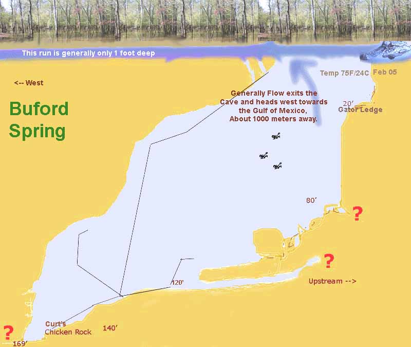
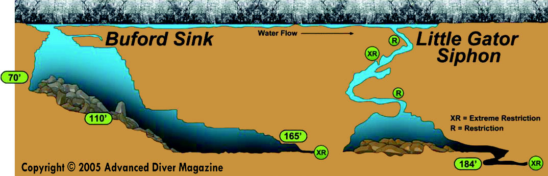
Except for times of heavy rain when the murky swamp water infiltrates the basin, all paths will eventually lead to an inviting blue pool of crystal clear water. The basin contains numerous fallen trees and is quite a beautiful site to those who appreciate nature, others may find it very spooky. The opening to the cavern is immediately obvious as you enter the basin, it is huge and depending on the angle of the sun, light will reflect off the sloping wall far below. As is slopes down at around 100' there is a small room off to the left side of the cavern. A little farther down is the start of a couple of guidelines that become useful since the cavern ceiling starts to block light from the entrance as you duck under and explore the deeper section. At 148', off to the right there is a pile of small breakdown blocking a hole that seems to have a positive flow.
Here are some additional excerpts from Walter Pickels tampaboating.com website:
Buford Sink was discovered in 1973 by Will Walters, who also discovered the DiePolder Sinks. Supposedly Buford Sink was named after Buford Register, an old cracker logger that Will talked into showing him the sink. It was off-limits/hunting property for years, but with the WMA now open, it is accesible. Many say that this is the second largest cavern in Florida, after Wakulla.
The dive is awesome. The maximum depth is 165' at the siphoning downstream end of the main
cavern/cave. The inflow comes from some outflowing areas at 140'. on the right side of the cavern, all this area seems to be a collapse zone that has eroded its way open to a small degree over a long time. There is also some slow flow from some low bedding planes on the left side of the cavern at 60-70'. The water that flows out of the sink goes 50 yards or so as a run, then syphons back down into a no-mount/sidemount crack that corkscrews its way down to 180 ft, where a large area of breakdown makes further passage difficult (but not impossible). It gets tannicy down there, and is flowing noticeably through a large room to the breakdown.
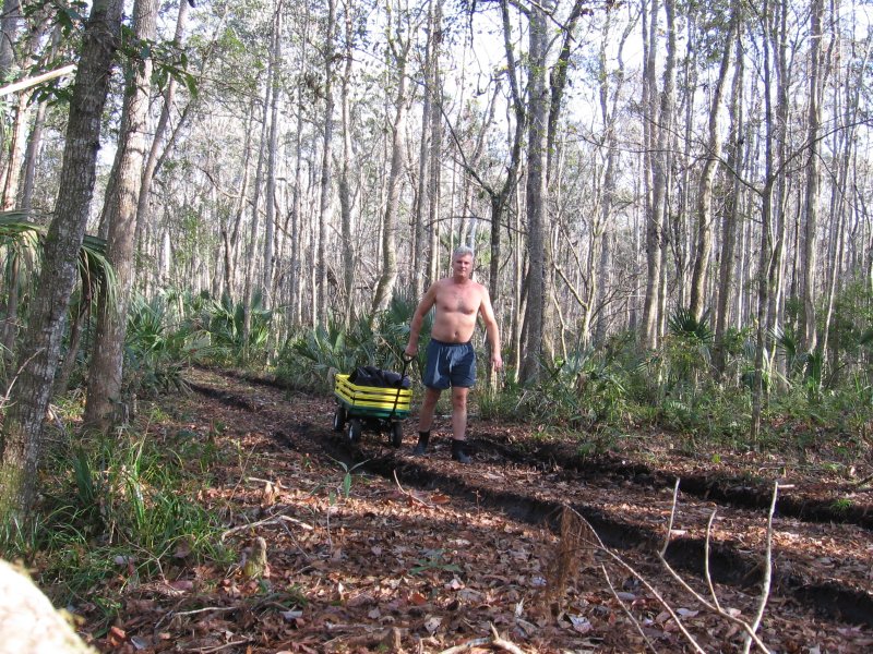
![]() Pulling a wagon load of gear down the tram road
Pulling a wagon load of gear down the tram road
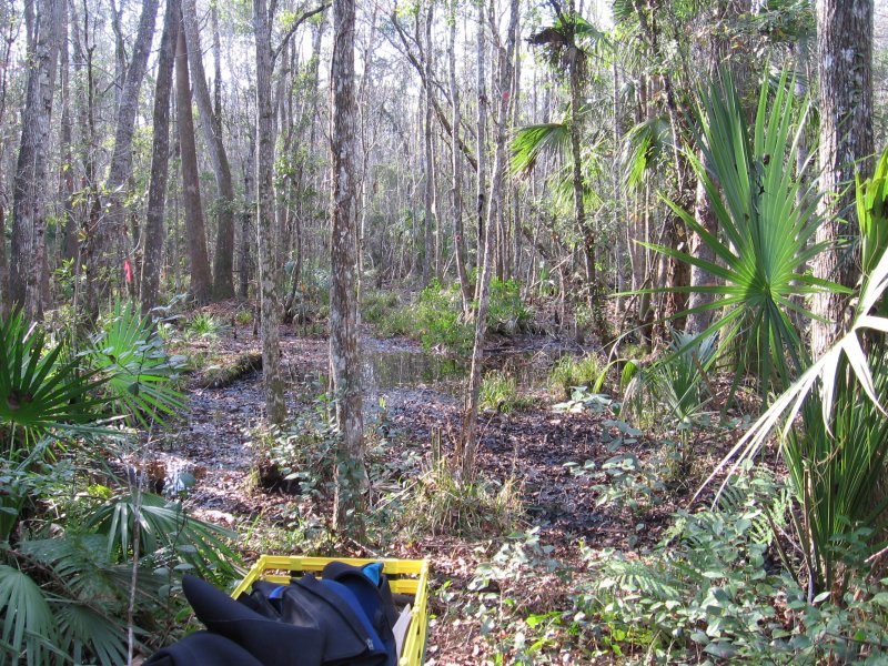
![]() End of the road, time to gear up and do the nasty
End of the road, time to gear up and do the nasty
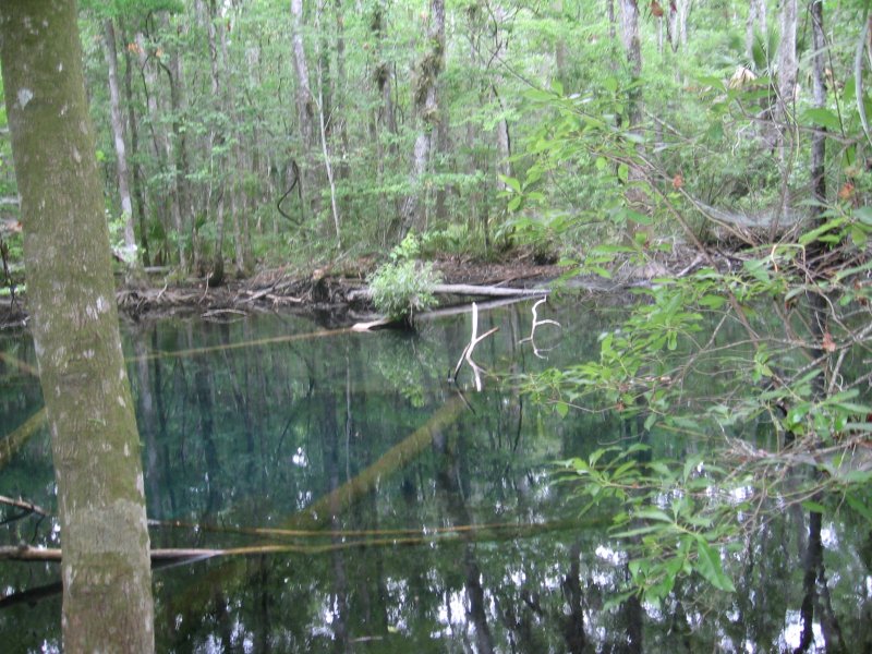
![]() Half-in / half-out of the water shot of the basin
Half-in / half-out of the water shot of the basin
![]() Short vid cap looking around cavern and out the entrance
Short vid cap looking around cavern and out the entrance
![]() Early Profile map of Buford Spring
Early Profile map of Buford Spring
![]() Better Profile map of Buford Spring
Better Profile map of Buford Spring

